The Livingston Manor Flood of 2006 - Fred Fries
June 28, 2006 - Livingston Manor, at least as far as
the media is concerned, both New York City and National, has become ground zero
for the flood of 2006. Don't be misled by this coverage, for our town is only
one of many communities that have been devastated by the week of drenching rain,
from northern Sullivan County and Delaware County toward Binghamton, in both the
Delaware and Susquehanna watersheds. We received the bulk of the media attention
only because of the tragic results.
Most of the flooding that occurs in our community has the same characteristics,
high water in the larger Willowemoc River daming the overabundant flow from the
Little Beaverkill, resulting in the flooding of the center of town. This recent
flood was slightly different, for though the above occured at record levels, it
was the smaller tributaries that created the most havoc.
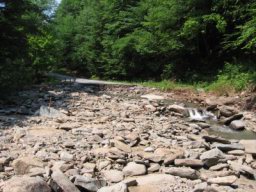
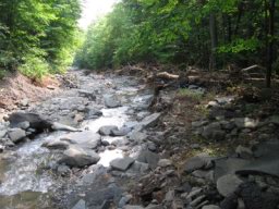
The Cattail Brook drains off the high lands of the Shandelee area, south of
Livingston Manor, and empties into the Willowemoc below River Street, down-river
of the center of town. Historically, this brook played an important role in the
development of our community; first, being the source for the first municipal
water company, numerous reservoirs dug near its course that supplied water for
the growing railroad town; second, providing the power for the first successful
water-powered electric generating plant, a dam being erected on the Cattail a
mile south of town; and third, providing the power to operate a saw mill,
possibly the first in the area, on the Livingston estate. The recent floods of
the past few years have left scars along its river-banks that never completely
healed, and in most cases were never physically stablized by the land owners, so
that with each high-water event, more and more of the banks were erroded away.
Conditions became ripe for tragedy when, coupled with the high rainfall this
spring, we received a week of soaking rain, completely saturating the ground
prior to the early Wednesday morning cloudburst.
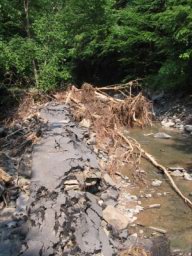
 The folks that reside on the Shandelee Road, just outside of town, along the
banks of the Cattail Brook were resting uneasy early Wednesday morning, for what
was normally the sound of a placid, bubbling brook was now the ferocious sound
of a raging river. Worried, they sat on their porches when, in the pre-dawn
darkness, they heard the sound of cracking and snapping of trees along the
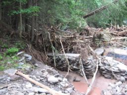
river's shores as these trees were being ripped off the banks and tumbling into
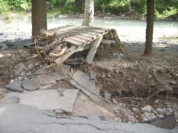
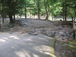
the river slamming into the first obstacle, the Hoos Street bridge. Some of the
timber went under, some went over and others lodged against this struture,
pushing the flow of water to the side, undermining the bridge's abutment and
collapsing half of the bridge into the torrent.
The folks that reside on the Shandelee Road, just outside of town, along the
banks of the Cattail Brook were resting uneasy early Wednesday morning, for what
was normally the sound of a placid, bubbling brook was now the ferocious sound
of a raging river. Worried, they sat on their porches when, in the pre-dawn
darkness, they heard the sound of cracking and snapping of trees along the
river's shores as these trees were being ripped off the banks and tumbling into
the river slamming into the first obstacle, the Hoos Street bridge. Some of the
timber went under, some went over and others lodged against this struture,
pushing the flow of water to the side, undermining the bridge's abutment and
collapsing half of the bridge into the torrent.
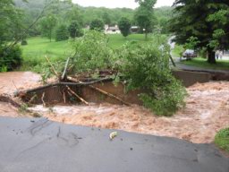
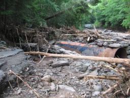
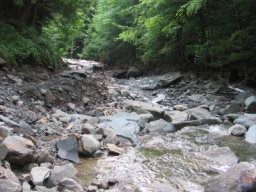
The rushing water, now with its load of timber, scoured the river's banks,
dragging more vegetation into its waters until the river and it's load struck
Simpson's iron bridge. Here, the bridge held, allowing the bulk of its load to
pass underneath, but not before being undermined at its abutment along the
Shandelee Road, shifting part of the stream's flow to over-run the highway and
begin its course upon the roadway towards town. For the next quarter mile there
was no differentiating between the river and the road.
Once past the iron bridge, the cauldron of river and trees slammed into the
Dayton bridge, a wooden structure on steel stringers, that quickly was washed
away. In this area, the river's banks had been lined with stone, walls that were
built from an earlier era when the old sawmill was in operation. Portions of
these walls caved into the raging waters, carrying with it the mammoth spruce
trees that once adorned the river's banks. This tidal wave of water, debris,
trees, stone and steel now continued its journey down-river to the deadly
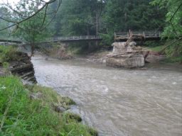
rendezvous with the Finch Street bridge.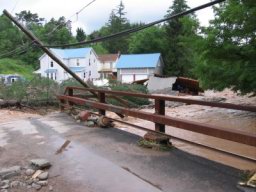
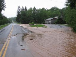
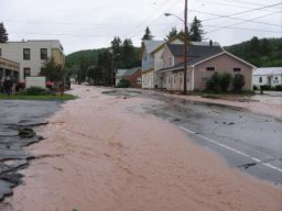
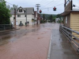
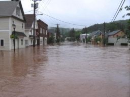
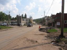
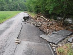
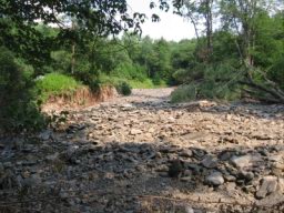
As the mass of river and its contents welled up behind the Finch Street Bridge,
a portion overflowed onto the Shandelee Road, now Upper Main Street, sending a
sheet of water over a foot deep cascading down the highway on its new course,
the street becoming the new river-bed. With the roadway having a crown in its
center, the running water was deeper along the sides of the street than in the
middle, effectively creating two seperate streams that cut its way through upper
Livingston Manor. On one side, the stream ripped up the pavement of the
intersection of Main and Finch streets, roiling past the McGrath building. A car
that was parked in front of the house was undermined as the stream cut a channel
along the side of the road, sending its back end into the resulting pit. A
blanket of running water ran through the Vitalie mill lot, washing away the top
surface of soil leaving behind the moonscape appearance of gravel and debris
throughout the yard.
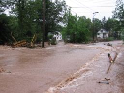
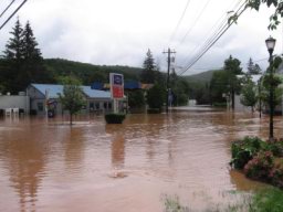
The entrance to the old steam laundry, next to the Masonic Hall, was washed
away, with a portion of the stream running behind the hall to Creamery Road,
leaving sand bars in its wake as it rolled over this side street and emptied
into the old Pud Rose house. The curbing in front of the Masonic building, town
library and the old post office either was washed away or sunk, leaving a trench
and numerous sinkholes along this route. This water came upon the DuBois house,
with its iron railing fence in front leaving the evidence of debris of just how
high this current was, and washed across the lawn, lot and residence.
The current that ran down the other side of Main Street ripped up driveways and
the intersections of Brown, Church and DuBois streets, sending water into the
basements of those residences on the lower end of these streets. For the first
time ever, floodwaters flowed through the firehouse. The parking areas in front
of both the laundramat and lawoffice were both ripped up. The slower moving
water in the center of the street left a trail of debris, broken pavement and
sand bars, all being supplied by these two side currents, throughout the length
of its journey.
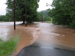
 The Cattail's water then flowed over the Main Street bidge, located over the
Little Beaverkill, as if it were a canal aquaduct from an earlier era. The
rampage caused by this flow ended on the other side of this bridge, as the
Cattail's waters entered into the relatively placid lake waters that had
engulfed the lower end of town, adding to the already record setting floodwater
height that the Willowemoc and Little Beaverkill provided.
The Cattail's water then flowed over the Main Street bidge, located over the
Little Beaverkill, as if it were a canal aquaduct from an earlier era. The
rampage caused by this flow ended on the other side of this bridge, as the
Cattail's waters entered into the relatively placid lake waters that had
engulfed the lower end of town, adding to the already record setting floodwater
height that the Willowemoc and Little Beaverkill provided.
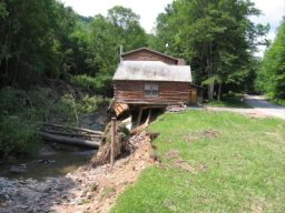
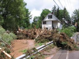 On the corner of Main and Finch streets, next to the Finch Street bridge, sits
the Brown building. Named for the color of the building, which recently was
painted white, it is an old, abandoned, small apartment building which sits on
the bank of the Cattail Brook, its concrete foundation being part of the river's
bank. With the recent flury of flooding, this foundation has been crumbling into
the brook, causing the building to lean out over the brook, so much so as for
local residents to make light of the situation as to when the building would
fall into the creek below. All joking subsided as the Cattail's floodwater's
rose and the building played a part in ensuing tragedy.
On the corner of Main and Finch streets, next to the Finch Street bridge, sits
the Brown building. Named for the color of the building, which recently was
painted white, it is an old, abandoned, small apartment building which sits on
the bank of the Cattail Brook, its concrete foundation being part of the river's
bank. With the recent flury of flooding, this foundation has been crumbling into
the brook, causing the building to lean out over the brook, so much so as for
local residents to make light of the situation as to when the building would
fall into the creek below. All joking subsided as the Cattail's floodwater's
rose and the building played a part in ensuing tragedy.
The building was condemned by the Town of Rockland a few years back, but
neglected to remove the structure, allowing it to stand precariously over the
river, waiting for the accident to happen.
***
 Flooding at Livingston Manor and vicinity reached record, and
in some cases dramatic, magnitude. Floodwater height in the village were at
levels never before seen. One of the culprits occurred in the Little Beaverkill
watershed when the dam at Denman Lake,
along the Dahlia Road, gave out, sending
a torrent of water down its outlet into the Little Beaverkill below above Morsston. At Morsston, homes were flooded, a trailer home destroyed, personal
belongings washed downstream and cars inundated.
Flooding at Livingston Manor and vicinity reached record, and
in some cases dramatic, magnitude. Floodwater height in the village were at
levels never before seen. One of the culprits occurred in the Little Beaverkill
watershed when the dam at Denman Lake,
along the Dahlia Road, gave out, sending
a torrent of water down its outlet into the Little Beaverkill below above Morsston. At Morsston, homes were flooded, a trailer home destroyed, personal
belongings washed downstream and cars inundated.
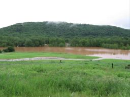
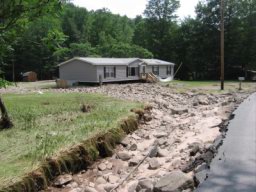
Further below on Mussman Flats, the Little Beaverkill rose over its banks and
crossed the highway, an event that never happened before. The basements of those
homes that were not flooded by the rising groundwater were filled with the muddy
overflow from the river. The runoff off of Roundtop, the hill across the road
from the river, was so great as to flood the basements of those homes that in
previous events were relatively high and dry. As the Little Beaverkill came into
town, residences and businesses along Pearl Street fell prey to the floodwaters
like never before. Alma Denman's house, which barely received water on the
kitchen floor the last time around, had water a foot and a half deep up inside.
On Meadow Street, the Guinan house, where a portion of the foundation collapsed
in the last flood and which was repaired, had the complete foundation wall on
the other side cave in. No one was spared the grief, some experiencing the muddy
mess for the third time within just a couple of years.
 Businesses were not spared on Main Street. Those who were paying attention
lifted items off of the floor, mitigating the damage, but for many of the
shopkeepers, this was a new, and painful experience. Barry Foster's memorabilia
sports shop, located in the stone building, next to the Adler building, was
particularly hard hit. A lifetime spent collecting autographs and sports
memorabilia were destroyed in just a few hours. Peck's Market, received water up
to the first shelf, the first time water ever got into the building.
Businesses were not spared on Main Street. Those who were paying attention
lifted items off of the floor, mitigating the damage, but for many of the
shopkeepers, this was a new, and painful experience. Barry Foster's memorabilia
sports shop, located in the stone building, next to the Adler building, was
particularly hard hit. A lifetime spent collecting autographs and sports
memorabilia were destroyed in just a few hours. Peck's Market, received water up
to the first shelf, the first time water ever got into the building.
 Over ten
thousand dollars of goods were piled out front, and since the water had only
risen partly up the containers they were still usable but unsellable. The items
were free for the taking. The staff at Pecks did a tremendous job in the
cleanup, having the store up and ready by Friday evening.
Over ten
thousand dollars of goods were piled out front, and since the water had only
risen partly up the containers they were still usable but unsellable. The items
were free for the taking. The staff at Pecks did a tremendous job in the
cleanup, having the store up and ready by Friday evening.
The Willowemoc River was at record height, floodwaters riding over the stone
walls of the school grounds. At the school's footbridge, the river sent a
continuous wave over the top, again the first time ever. Portions of the earthen
dike below the ball fields disappeared allowing the muddy waters onto the lower
fields. At Fulton Park, more of the lawn area eroded away. The water flowed over
the top of the floor deck of the band shell, again for the first time.
By the middle of Wednesday afternoon, Main Street drained out, allowing
shopkeepers to survey the damage and for some begin the arduous task of the
cleanup. Due to the heavy amount of rain and the saturation levels of the
ground, the water on Pearl Street did not recede until late afternoon.
 Downriver from town, the flood raised its usual havoc. Lower
River Street flooded. Water from the Willowemoc came up on, and into the
residences located on the old O&W railway bed along the Hazel Road. At Mott's
Flats, the floodwater again ponded up as a result of the undersized sluice under
Route 17. At the lower end, the residents who were most effected by last year's
flood decided to stay. Dirt and fill were brought in to raise the level of their
modular homes above last years high water mark, what was considered the one
hundred year flood and the highest level floodwaters would attain. Water rose up
into the homes and the folks had to rescued off of their roofs.
Downriver from town, the flood raised its usual havoc. Lower
River Street flooded. Water from the Willowemoc came up on, and into the
residences located on the old O&W railway bed along the Hazel Road. At Mott's
Flats, the floodwater again ponded up as a result of the undersized sluice under
Route 17. At the lower end, the residents who were most effected by last year's
flood decided to stay. Dirt and fill were brought in to raise the level of their
modular homes above last years high water mark, what was considered the one
hundred year flood and the highest level floodwaters would attain. Water rose up
into the homes and the folks had to rescued off of their roofs.
 Below Deckertown, the last few floods choked the river-bed with gravel, the top
of the gravel bar being pretty much the height of the river's banks. The
floodwaters were easily pushed up over these banks and flowed across old route
17 into the trailer park below. Some trailers were pushed off their foundations,
others inundated. Toppled fuel oil tanks spewed their contents adding the
pungent odor throughout the area. At Hazel, most of the remaining stonework of
the old O&W bridge abutment fell into the river.
Below Deckertown, the last few floods choked the river-bed with gravel, the top
of the gravel bar being pretty much the height of the river's banks. The
floodwaters were easily pushed up over these banks and flowed across old route
17 into the trailer park below. Some trailers were pushed off their foundations,
others inundated. Toppled fuel oil tanks spewed their contents adding the
pungent odor throughout the area. At Hazel, most of the remaining stonework of
the old O&W bridge abutment fell into the river.
At Roscoe, the flood was most devastating. Water trapped on the upper side of
Route 17, which bisects the town, completely flooded the business section and
residences. Some foundations were undermined and partially collapsed. Last year,
the floodwater went into the Roscoe Library at a depth of about a foot, the
first time water had ever been in the building. This year, the water line inside
the building was almost four feet. The O&W museum received about two feet of
water, destroying exhibits, photographs, books and equipment. With the dried mud
and silt on the streets creating minor dust storms and with the ruined
possessions of the victims piled pitifully in front of their homes, the town is
now filled with summer residents and tourists dressed in their summer regalia,
offering a sharp contrast with those currently living in misery.
This flood will be forever remembered for the drama that
unfolded at Finch Street and for the height of the floodwaters within the
village [30 inches at the pharmacy, 6 feet at Shaver's Mayflower], but it will
also be noted for the destructive and dangerous conditions created by the
smaller creeks and tributaries.
 The
lower end of Elm Hollow Road, above Deckertown, was completely destroyed. The
sluice became plugged with an amazing pile of timber forcing the Elm Hollow
Creek to jump across the road, wiping out a section of road almost one hundred
yards in length. As this froth reached the county road below the town highway
department's facilities, the bridge filled with debris and the floodwaters piled
over its banks and crossed the highway, carrying its load of debris and gravel
with it. It struck the Laky house, piling gravel and large boulders upon the
building and pushing it off the foundation. Further below, it became a blanket
of water as it washed over the lawns of the residences and through the houses.
It breached the dam of the Smith pond, adding even more water to the wave of
floodwaters.
The
lower end of Elm Hollow Road, above Deckertown, was completely destroyed. The
sluice became plugged with an amazing pile of timber forcing the Elm Hollow
Creek to jump across the road, wiping out a section of road almost one hundred
yards in length. As this froth reached the county road below the town highway
department's facilities, the bridge filled with debris and the floodwaters piled
over its banks and crossed the highway, carrying its load of debris and gravel
with it. It struck the Laky house, piling gravel and large boulders upon the
building and pushing it off the foundation. Further below, it became a blanket
of water as it washed over the lawns of the residences and through the houses.
It breached the dam of the Smith pond, adding even more water to the wave of
floodwaters.
 Because
of the three floods within the last two years, the Elm Hollow Creek bed had
become filled with gravel before the bridge on old Route 17 at Deckertown.
Attempts by local residents to have this gravel removed were denied by the DEC.
With the river's channel filled with gravel, the floodwaters easily went over
the road, ripping up trees and pavement and flooding the cabin that sits across
the road on the bank of the Willowemoc. It also completely surrounded the DeWitt
house with raging current, destroying the lawn and driveway, carrying away the
garage and its contents. The house received little damage. A large oil tank
wound up laying in the middle of road, turned on it side, and spilling its
contents, the odor that still lingers today.
Because
of the three floods within the last two years, the Elm Hollow Creek bed had
become filled with gravel before the bridge on old Route 17 at Deckertown.
Attempts by local residents to have this gravel removed were denied by the DEC.
With the river's channel filled with gravel, the floodwaters easily went over
the road, ripping up trees and pavement and flooding the cabin that sits across
the road on the bank of the Willowemoc. It also completely surrounded the DeWitt
house with raging current, destroying the lawn and driveway, carrying away the
garage and its contents. The house received little damage. A large oil tank
wound up laying in the middle of road, turned on it side, and spilling its
contents, the odor that still lingers today.
 If awards
were to be handed out for the most devastated area in our section, the winners
could possibly be the folks along the Grooville Road. Normally, Sprague Brook
runs peacefully along side of the Grooville Road throughout this narrow valley.
Throughout the past few years, where there was room between the road and river,
small residential lots were sold off, with the town's approval, filling the
valley with residences that in some cases were located in abandoned stream
channels from the geological past. As Sprague Brook became a raging torrent,
floodwaters ran through residences, collapsing garages and sheds, carrying away
the family campers, destroying vehicles, washing away lawns and leaving a
bouldery landscape.
If awards
were to be handed out for the most devastated area in our section, the winners
could possibly be the folks along the Grooville Road. Normally, Sprague Brook
runs peacefully along side of the Grooville Road throughout this narrow valley.
Throughout the past few years, where there was room between the road and river,
small residential lots were sold off, with the town's approval, filling the
valley with residences that in some cases were located in abandoned stream
channels from the geological past. As Sprague Brook became a raging torrent,
floodwaters ran through residences, collapsing garages and sheds, carrying away
the family campers, destroying vehicles, washing away lawns and leaving a
bouldery landscape.
 Much of
Davenport Road washed out, piling an impassible mound of gravel upon the
Grooville Road. Where the brook was in close proximity with the road, much of
the road was washed away. One washout sliced through the pavement below the Paul
Devoe farm, making the road impassible. Paul Devoe's bridge, that was replaced
after the last flood received some damage but remained on its abutments. Richard
Hankin's bridge, which was replaced two floods ago, had some of its abutment
blocks tumble away causing the bridge to fall onto a lower layer of blocks but
not into the river.
Much of
Davenport Road washed out, piling an impassible mound of gravel upon the
Grooville Road. Where the brook was in close proximity with the road, much of
the road was washed away. One washout sliced through the pavement below the Paul
Devoe farm, making the road impassible. Paul Devoe's bridge, that was replaced
after the last flood received some damage but remained on its abutments. Richard
Hankin's bridge, which was replaced two floods ago, had some of its abutment
blocks tumble away causing the bridge to fall onto a lower layer of blocks but
not into the river.
 Above
the O'Mara place, the round culvert that had caused so much trouble for the
O'Maras during the last floods was replaced with a box culvert last summer and
for the most part carried the flow under the highway. Unfortunately, the river
jumped its banks below the culvert and flooded the O'Maras again, the third time
in two years.
Above
the O'Mara place, the round culvert that had caused so much trouble for the
O'Maras during the last floods was replaced with a box culvert last summer and
for the most part carried the flow under the highway. Unfortunately, the river
jumped its banks below the culvert and flooded the O'Maras again, the third time
in two years.
Poles that were alongside the brook toppled over, disrupting phone service for
days.
Though nobody got hurt here, it was not totally without incident. Throughout the
morning of the flood, a rumor spread that one of the local firemen was missing.
Richard Dane, from Grooville, attempted to answer the early morning fire call at
the Manor but was unable to get through. Meanwhile, the road washed out behind
him, stranding him between washouts. With phone service out, and no word from
Richard, the worst was feared, reminiscent of an earlier Grooville flood in the
late 1890's when one of the Koons brother's horse and wagon fell through a
bridge and all were swept away. Fortunately, Richard was found to be safe. Up
the road, a van with two occupants from one of the children's camps had gone
into the creek. Rescuers retrieved them from the water with a rope, but not
before a scary incident when one of the victims was swept into the current. Both
survived, wet but unharmed.
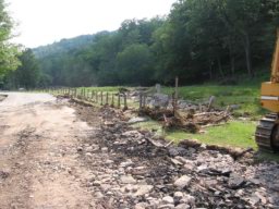
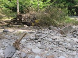
Cattail Cleanup Begins

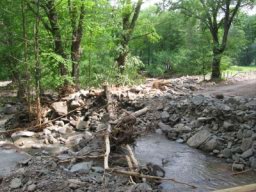
Upper Main Street Aftermath
In the Beaverkill Valley, the damage from the flooding was no less intense than
at the Willowemoc watershed. Shin Creek created havoc along the Shin Creek Road
beginning with the washout of the bridge above the Hunt barn. Numerous washouts
and landslides either limited travel or blocked the road completely. The worst
was across from the Irving Berlin estate where either the road was washed out
and created a landslide or a landslide helped slump the road into the brook.
Either way, the road was completely destroyed for almost two hundred feet,
falling into the creek and washed away along with the bridge that served the
driveway for the Berlin family, stranding them at their home for several days.

At Lew Beach, the Shin Creek overflowed its banks, washing away lawns, going
through the Lloyd Mann garage and blowing out one of the walls, and flowing into
the buildings and residences of the community below with its load of gravel and
mud.
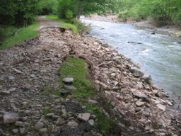
Along the Beaverkill Road, Gee Brook, above the Beaverkill Trout Club, which was
choked with gravel from the last flood and never attended to, overflowed its
channel and washed a section of the Beaverkill Road out. The lawn of the
Beaverkill Trout Club, on the side of the river, which once extended almost one
hundred feet from the road to the Beaverkill River's bank, and had been eroding
away with each flood, is now completely gone, the river now lapping upon the
shoulders of the highway.
 The
bridges across the Beaverkill that serve the private residences were all damaged
to some degree, some more serious than others. The most serious was the Willich
bridge where a section of the bridge washed away. The old Lew Beach iron bridge
received damage along its abutment.
The
bridges across the Beaverkill that serve the private residences were all damaged
to some degree, some more serious than others. The most serious was the Willich
bridge where a section of the bridge washed away. The old Lew Beach iron bridge
received damage along its abutment.
One of the most popular campsites in our area, the Beaverkill
 Campsite,
is now closed and judging from the damage, will have a hard time being able to
open again this season. Roads in the campsite were washed away, including some
of the utilities that served the individual sites. Picnic tables were strewn
across the grounds and piled upon trees and shrubs along with the rest of the
debris, including sleeping bags and tents. The fire pits, a rather hefty chunk
of stone, concrete and steel were upended and tossed around at most of the
camp-sites.
Campsite,
is now closed and judging from the damage, will have a hard time being able to
open again this season. Roads in the campsite were washed away, including some
of the utilities that served the individual sites. Picnic tables were strewn
across the grounds and piled upon trees and shrubs along with the rest of the
debris, including sleeping bags and tents. The fire pits, a rather hefty chunk
of stone, concrete and steel were upended and tossed around at most of the
camp-sites.
At Rockland, the Beaverkill flooded the Roscoe Motel, again, with water reaching
record heights to the top of the motel rooms. At the Roscoe Central School's
athletic field, the water reached the height to the top of the fence that
surrounds the tennis court, which was ten feet, and collapsed the fence.
Downriver, towards Cook's Falls, the private campsites were partially destroyed,
again, and numerous washouts along old Rout 17. At Cook's Falls, the USGS river
gauging station, the only one that is located on the Beaverkill and Willowemoc
watersheds, was overwhelmed and ceased operating, losing accurate information
concerning the flow, volume and height of the rivers' floodwaters.
 The
ingredients for the perfect flood all came together along the valley where the
Elm Hollow Brook runs. Estimates as high as twenty inches of rain, almost half
of the yearly total average for our area, had fallen over a five day period.
During the last twelve hour period of the event, five inches of rain fell. All
this rainfall saturated the ground, leaving a spongy mass, unable to hold
together against the onslaught of rushing water. Earthen dams were particularly
vulnerable, the dam turning into a wall of mud holding against the pressure of
the rising waters behind it.
The
ingredients for the perfect flood all came together along the valley where the
Elm Hollow Brook runs. Estimates as high as twenty inches of rain, almost half
of the yearly total average for our area, had fallen over a five day period.
During the last twelve hour period of the event, five inches of rain fell. All
this rainfall saturated the ground, leaving a spongy mass, unable to hold
together against the onslaught of rushing water. Earthen dams were particularly
vulnerable, the dam turning into a wall of mud holding against the pressure of
the rising waters behind it.
The lower portion of the Elm Hollow valley is narrow as the river cuts through a
glacial morraine before widening out into the Willowemoc valley. Here, the Elm
Hollow Brook and highway both compete for the same space, running side by side
for over a mile. Past flooding episodes would see flood damage along some of the
edges of the road which the town would quickly repair. That will not happen this
time for the Elm Hollow Road in this lower section can be said no longer exists,
the river completely destroying the road, leaving very little evidence of its
previous existence.
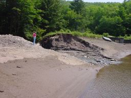
 Due
to the narrowness of the valley, few residences were in this section, but those
that were took the brunt of the river's fury. Above, was a small pond, an
earthen dam holding back its contents. Floodwater ran over the top of the dam,
slicing a breach that wound up over twenty feet wide, allowing all of its
contents to spill down river. Down river, the Neal log-cabin
Due
to the narrowness of the valley, few residences were in this section, but those
that were took the brunt of the river's fury. Above, was a small pond, an
earthen dam holding back its contents. Floodwater ran over the top of the dam,
slicing a breach that wound up over twenty feet wide, allowing all of its
contents to spill down river. Down river, the Neal log-cabin
 was
situated across the creek from a steep embankment. The wall of water from the
breached dam undermined this embankment, causing a slide that started at least
fifty feet high and over one hundred feet wide to crash onto the creek's bed
below, the stone, mud and trees pushing the raging floodwaters onto the lawn and
foundation of the Neal cabin. The lawn quickly washed away as was most of the
building's foundation, along with a portion of the floor of the building's first
story, leaving the building precariously overhanging the newly excavated
creek-bed. Steel beams used in the foundation can be found a quarter of a mile
down-stream.
was
situated across the creek from a steep embankment. The wall of water from the
breached dam undermined this embankment, causing a slide that started at least
fifty feet high and over one hundred feet wide to crash onto the creek's bed
below, the stone, mud and trees pushing the raging floodwaters onto the lawn and
foundation of the Neal cabin. The lawn quickly washed away as was most of the
building's foundation, along with a portion of the floor of the building's first
story, leaving the building precariously overhanging the newly excavated
creek-bed. Steel beams used in the foundation can be found a quarter of a mile
down-stream.
 From
here on down, for a distance of about a mile, the river completely swept away
the pavement and cut a new channel, in some cases six feet deeper than the
original pavement level, where the road once stood. On occasion, a small section
of the road survived, heavily damaged. Otherwise, throughout the length of a
mile, the valley is now a gulch of gravel, boulders and fallen trees. Two
residences on the lower end appears to have received little structural damage,
but are completely isolated due to the erosion, unable to be reached by
conventional vehicles.
From
here on down, for a distance of about a mile, the river completely swept away
the pavement and cut a new channel, in some cases six feet deeper than the
original pavement level, where the road once stood. On occasion, a small section
of the road survived, heavily damaged. Otherwise, throughout the length of a
mile, the valley is now a gulch of gravel, boulders and fallen trees. Two
residences on the lower end appears to have received little structural damage,
but are completely isolated due to the erosion, unable to be reached by
conventional vehicles.
The damage to this road is so extensive, it is hard to fathom how the highway
department will be able to fix, actually rebuild, this section and find the
funding for such a project.
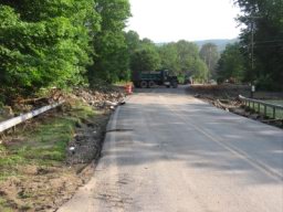
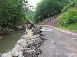
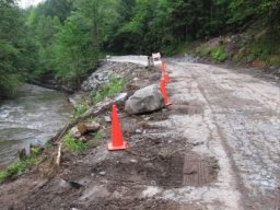
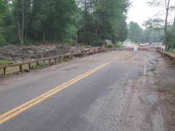
Two weeks after the flood of '06, Livingston Manor and
vicinity are slowly being picked up and pieced back together with life returning
to normal, though normal may be in a different context nowadays. Within two days
of the flood, the Sullivan County Department of Public Works did the herculean
task of putting the Shandelee Road along the Cattail Brook back together and by
that Friday night, the river was back in its channel and the approach to the
Hoos Street bridge was opened again, allowing the stranded Finch Street
residents to get out off of their battered street. County workers have also made
makeshift repairs to the trenched drainage ditches along the Beaverkill Road,
Old Route 17 and the Willowemoc Road rather quickly. Road cones noting these
hazards are very much part of the landscape. Even the site of the crater created
at Finch Street doesn't shock the local observer anymore as we go about our
daily business.
The Town of Rockland now has the seriously damaged Grooville Road opened up
again recently, but repairs will be needed on many of the shoulders of the
town's roads, including Little Ireland, White Roe Lake, Beaver Lake, Back
Shandelee, Hazel, Cattail as well as other town roads. Elm Hollow may be a
different story.
Piles of water-logged furnishings and debris had been piled in front of the
residences who were damaged by the river flood-waters or ground-water flooded
basements. As of today, most had been picked up and carted away by prison
inmates to waiting dumpsters at the school grounds.
The Red Cross people are beginning to pull out of the Livingston Manor Central
School facilities, moving their base of operations to Port Jervis. The void
created by their leaving is being filled by FEMA, as well as numerous Sullivan
County and state agencies, now inundating the flood victims with a flood of
paperwork and promises. Hopefully they will do better than a heck of a job they
have done in the past.
This coming Thursday evening the Town's officials will hold what will probably
be the first of many community meetings, at the firehouse, which promising to be
a rousing affair. The difference of opinions on how to manage the local rivers
is as wide as the newly widen streams, and the Finch Street tragedy will
certainly change the dialogue on this discussion. With the memory of the
disaster still fresh in our minds, participants will be tracking in the
remaining river-mud from The firehouse's parking lot, offering evidence on the
soles of their shoes of the events that unfolded only two weeks ago.
***************
Fred Fries - July 4, 2006
******************************
Epilog
Its been over six weeks since the flood of '06 and a lot of
water has gone over the dam, at least over the dams that have survived the June
28th deluge. Town and county highways have been either repaired or temporarily
patched as to allow relatively save passage over their routes; blaze-red traffic
cones being very much part of our landscape these days. Equipment was allowed
into the smaller streams, clearing debris and removing gravel. The Little
Ireland Brook was cleaned out and re-positioned back into its original channel
next to the Darbee house on the Beaverkill Road and also between the Lamoreaux
and DeWitt residences on Old Route 17 at Deckertown. Ditches have been repaired
on the county road over Johnston Mountain and the road-shoulders shored up below
the Beaverkill Trout Club along the Beaverkill Road. Beaver Lake Road still has
eroded sections along its route going over the hill from Morsston but remains
passable, albeit single lane in some locations. Though some work occurred in
clearing Sprague Brook along the Grooville Road, it is still an ugly scar all
along its course, filled with toppled trees and lined by landslides. Private
bridges here, as well as along the Cattail Brook and Beaverkill River, still are
either missing are in need of repair, an inconvenience for those residences. The
lower end of the Elm Hollow Road will be another story; being abandoned for now
until enough money can be found to rebuild the washed-out section.
The flood of relief workers, Red Cross, and its fleet of Hummers, and FEMA have
finally vacated the school premises, leaving a trail of rotting wastepaper
baskets full of pizza, discarded cigarette butts and boxes of unused care
packages, all needing to be picked-up by somebody. Just who does pick up after
the Red Cross and FEMA anyway?
Word is out that the displaced Finch Street families are finding permanent
residences back in our community. As for the Finch Street disaster site, it
still looks like a disaster, though the river-scoured craters are being filled
in with river gravel. For the past month, residences above this site needed to
be supplied with town water from the upper fire-hydrant along Shandelee Road.
They are now back on line. The sewage leak into the Cattail Brook still exists,
though the town has been working on the problem, and the situation has improved.
The talk of the town is still about the flood. A normal conversation on Main
Street most likely goes like this; "Hi, how are you, let me tell you what I
think about the flood!" It seems nowadays that everybody has an opinion on what
causes the floods and the remedies that need to be taken. Those more emboldened,
or just plain more opinionated, have taken to writing letters to the local
tabloids expressing their theories for all to see. One such opinion came from
Town of Rockland's supervisor in her monthly address to the community. In her
column, she attempts to swing the blame from "someone else, usually the
government" to the flood-victims themselves. "Many people still do not have
flood insurance despite repetitive flooding" she claims, though many are either
denied this coverage or simply cannot afford the costs. She later states, "Many
people watched the river for two days and yet did nothing to prepare for the
flood." When flood-waters reach a height of five feet, as it was on Pearl
Street, how high do you raise your belongings off of the floor?
The callousness of these remarks seem to indicate that the compassion for our
flood victims, those who have experienced being flooded-out three times in the
last two years, is gone and the "let them eat cake" attitude now prevails among
our local leaders.
Another of the letters sent to The Towne Crier concerning the recent flood was
authored by Vera Johnston Farrell. Titled "Toughest School Lesson," Vera pins
the blame of the Livingston Manor floods upon the construction of the central
school, calling it "what may be the single greatest man-made cause of our
present situation." Now, this isn't the first time that this argument has been
proposed. Alan Fried, at the first "Stream Team" meeting sponsored by the town,
first made the suggestion that the school grounds, with the stone walls that lie
within fifty feet of the Willowemoc River's banks somehow cause the flooding in
town. Their assertion that "this was the only area which for untold years had
collected and absorbed the flood waters from the juncture of the Willowemoc,
Little Beaverkill, and Cattail was now nothing more than a dam during the high
waters" brings their reasoning into a historical perspective, but it is an
argument that just simply doesn't hold water.
To blame one particular historical event, such as the building of the central
school, tends to ignore the more than one hundred and thirty years of village's
development in the Willowemoc-Little Beaverkill flood-plain. Each and every
project that occurred during this time has added to the problem. First off, it
should be noted, that throughout recorded history, except for the Willowemoc ice
jam of around 1915, the flooding of Livingston Manor is caused by the waters of
the Little Beaverkill overflowing its banks. In 1894, in order to ease
transportation problems across the Little Beaverkill, an iron bridge was erected
on what was to become Main Street, linking the commercial side of the village,
with its railrod connection, to the manufacturing section, consisting of the
turning mill and grist mill at Purvis and access to the mills at DeBruce. The
bridge, sat high over the river, but was not long enough to allow any increase
flow that the river's flooding would create. High water that occurred shortly
after the bridge's completion simply went around the bridge, washing out the
northern approach. This approach was well below the height of the bridge,
necessitating a steep climb onto the bridge from this direction, so the town
authorized the filling in of the approach, on lands that it did not own (the
land was owned by Jack Sherwood which is another story in itself), raising the
level of the street and further impeding the flow of the Little Beaverkill.
The creation of the iron bridge now led to the development of the lower end of
town. The blacksmith shop, harness shop and "Center of Town" store were already
in place on the Main Street, but were not located along the river. At the iron
bridge, with the elevated fill at both ends, Fred Hoos was allowed to the bakery
in 1903 on the northern side, its foundation and building supports forming the
northern banks of the Little Beaverkill. The following year, James Stevens moved
his hardware store, which was originally an addition to his residence on
Pleasant Street, to the southern side of the Little Beaverkill, its foundation
walls further restricting the width of this river, a problem the village deals
with each and every flood that occurs.
The next thirty years saw major development along Main Street, particularly
along the banks of the Willowemoc River. The Neumann building, the hotel at the
bridge, as well as the amusement hall behind, required fill. Fontana shored up
the Willowemoc riverbanks when he had the theatre erected in 1922 as well as
fill in behind his fruit and vegetable store for gardens. Thomas Dawson filled
in his lot and the neighboring lot to raise the foundry buildings above the
Willowemoc flood waters. As evidenced by early postcards showing the lower end
of town, Main Street itself has been raised, a process that continues with each
layer of macadam laid on its surface, raising the road's elevation. A walk along
this section of the river today shows the level that the banks were raised as
well as the stonework necessary to stabilize the river's banks. Using Vera's
words, the "area which for untold years collected and absorbed the floodwaters"
(the lower Main Street area) was now developed and restricting the historical
flow of the Willowemoc floodwaters, maybe even more so than the school property.
Reading Vera Farrell's letter to The Town Crier, one would gain the opinion that
the school property was one vast reservoir of floodwater whenever the town
became inundated. In fact, she states its the "only area which collected flood
waters" in our town for which, as previously stated, she is not correct.
Evidence also seems to disprove her theory concerning the role the present
school property, originally called Island Park, historically played in previous
flooding, before the central school was built in 1938.
The case of Charles Victor Livingston against the residents of Livingston Manor
who resided on the original Edward Livingston farm brought two noted
personalities to the area. Eugene Bouton, an attorney, legally represented
Livingston and his holdings at the local level, and Lawrence McGrath as the
surveyor. McGrath, and later his son Charles, did a tremendous amount of survey
work in the immediate vicinity over the years, some of which I have placed on
the "Photos" site under the category of "maps". One map in particular seems to
throw water on the firestorm that Vera is trying to create.
During the early spring of 1936, before the erection of the Livingston Manor
Central School, Livingston Manor was flooded. Charles McGrath recorded the
extent of the floodwaters on a map which is reproduced on the "Photo" site. With
yellow chalk lines, he notes the extent of the floodwaters and with finer white
arrows, notes the flow the floodwaters travel. As far as the flooding shown in
the downtown portion of Livingston Manor, the yellow lines that McGrath drew on
April 10th, 1936, are in the exact same location where the floodwaters reached
during all of our recent floods. The flow lines represented on the maps, prove
that this particular flood was a result of the overflowing of the Little
Beaverkill, an occurrence that still exists today, school or no school.
As far as the Island Park being a vast reservoir of Willowemoc floodwaters, the
flooded area on the map doesn't appear to be all that large. The original Island
Park was a 37 acre, the central school district buying 26 acres off of Eugene
Bouton, between the raceway and the river. McGrath's location of the flooded
portion appears to be less than half of the lot, less than ten acres, hardly the
vast reservoir that Vera would have you believe.
Today, the school's stone walls that are set back off of the Willowemoc's
riverbank fifty feet, and run a good portion of the property, allowing that
section of the property to be inundated. This area between the wall and the
river estimates to be around three acres. The walls are also not flood proof,
for there are breeches in the wall, at the upper and lower ends, that allow
water onto the premises, both onto the upper playground and the lower ball
fields. Both areas were flooded in the past two floods, as well as the flood of
1969. Though the landscape has changed due to the construction of the school
grounds and surely some floodwaters are kept off of the premises and into the
Willowemoc's channel, this is certainly not "the single greatest man-made cause
of our present situation" but rather one of many projects developed over a
prolonged period of time throughout the history of our village along both sides
of the Willwemoc River that all contribute to each and every flooding episode.
fred